Skip to content

The pH-alkalinity gradient in space and time, an ecological framework for freshwater biodiversity (ALKALDIA)

ALKALDIA

This work focuses on addressing our general hypothesis that local diatom communities respond to the direct and watershed-mediated effects of the current increase in atmospheric CO2, providing insight into small-scale alkalinity generation mechanisms.

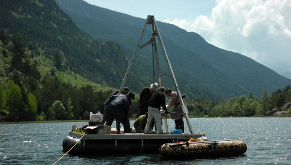
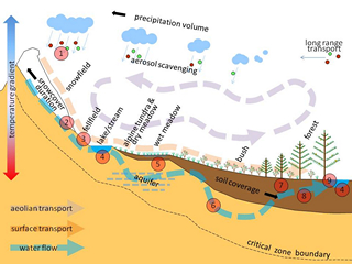
The overall aim of this project is to elucidate the biogeochemical processes that control the pH-alkalinity variation at fine scales in mountain aquatic sistems (e.g. microhabitats, interannual and decadal tendencies and fluctuations, changes across vegetation gradients), providing the reference to characterize the fluctuations that local diatoms communities may experience. This work is focused to address our general hypothesis that local diatom communities are responding to direct and catchment-mediated effects of the current atmospheric CO2 increase, by providing insight into the small scale mechanisms of alkalinity generation. Our specific working hypothesis in this subproject is that the aggregation of such fine scale mechanisms gives rise to mesoscale patterns/gradients of alkalinity (both in space and time), that are the ecological framework in which local communities evolve. The conceptual basis for this analysis is the Landscape Continuum Model (LCM) applied to high mountain catchments.

Duration: June 2020 – May 2023

Funding Agency: Ministerio de Ciencia e Innovación

LOOP participants: Jordi Catalan, Marisol Felip, Lluís Camarero, Sergi Pla

Coordinators : Jordi Catalan, Lluís Camarero

Participant institutions: CREAF, University of Barcelona, CEAB-CSIC

General project information

Development period
Start

June 2020

End

May 2024

Department

Responsible researcher

Tenured Scientist

Other researchers and involved staff

Funding entities

Institutions/collaborators

Social networks of the project

You may also be interested in

Cross-border project to detect and monitor non-indigenous marine species in Catalonia and Occitanie, enhancing scientific cooperation, citizen participation, and management of impacts on ecosystems and coastal economies.
DryingLake addresses the problem of inland water desiccation, which is increasingly affecting ecosystems worldwide due to both climate change and the diversion of water for irrigation.
By combining satellite images, remote sensors, and field data, the project will provide effective tools to help managers and policymakers monitor and assess coastal carbon ecosystems and integrate blue carbon into national climate inventories and policies.
The Network's main objective is to foster collaboration between national and international research groups to advise society and authorities on the key role of BCEs.
It proposes to develop an innovative and non-destructive method to quantify carbon stocks. This method will use advanced technologies such as geoacoustics, autonomous vehicles, drones, satellite imagery and artificial intelligence, also allowing the exploration of “hidden” carbon deposits under layers of sediment, which have so far been ignored.