The overall goal of the MOBVEC project is to create a technology that will be the first line of defense against disease vectors, help prevent and combat devastating disease outbreaks, and save lives and millions of euros in healthcare and lost work hours.
MOBVEC will be the first VBD Mobile Bio-Lab in the world, offering a global service:
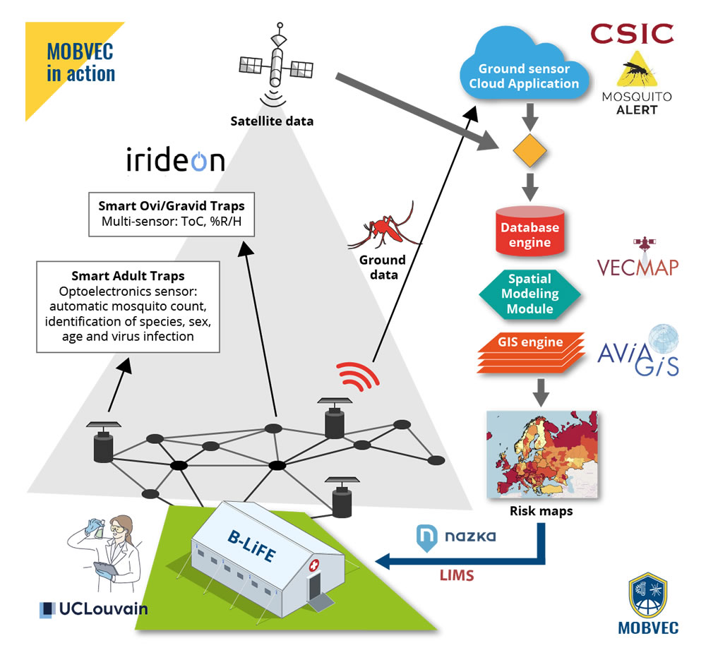
– Automatic information on vector populations and their environment, obtained in real time through smart traps, powered by machine learning and cutting-edge computing: insect species, sex, age and viral infection.
– GEOSS-compliant adult insect vector risk maps and eggs/larvae, built in the field + Copernicus data
– GEOSS-compatible disease transmission models in mosquito populations, merging data provided by a) Copernicus, b) clinical and diagnostic data from reference laboratories, and c) vector risk maps
– GEOSS-compatible citizen science platform to strengthen mosquito surveillance using citizens as observation nodes, whose data is automatically calibrated using data from smart traps.
– Mobile BD biolaboratory with capacity for points 1, 2 and 3 + BDV epidemiological maps, prognostic models and molecular analysis of arboviruses, which will be quickly operational in the heart of BDV outbreaks to support emergency personnel.
Development of biolaboratory protocols with biological samples:
- Protocol to test new smart traps with different species of disease-carrying mosquitoes
- Breeding specimens of mosquitoes of different species for laboratory tests.
- Field collection of specimens in immature stages (eggs, larvae or pupae) using the INSA mosquito control program.
- Implementation of new on-site tests for viral detection: NGS (next generation sequencing)
- Development of an optimized method for the conservation and transport of viral RNAs
- Development of a protocol for the deployment of terrestrial sensors with a deployable biolaboratory in case of outbreaks
- Development of a deployable biolaboratory protocol to work with local health authorities in VBD outbreak scenarios
- Development of VBD EO models using EGNSS, COPERNICUS and GEOSS:
- Implementation of Sentinel 3A products to obtain vegetation and temperature data
- Implementation of the ESA SNAP framework to save time and money and our MODIS processing chain
- Implementation of other Copernicus Global Land Service products for vegetation (e.g. products derived from Proba-V)
- Implementation of algorithms to correct error sources (e.g. clouds) and obtain seasonal data components.
- Benchmarking of existing data sets (such as MODIS) performed at different stages of the processing chain. The Fourier results will be compared and the influence of the different products on the accuracy of the model will be verified.
- Development of vector risk maps and SDSS with real-time field data from EGNSS-compatible ground sensors. Finding the best synergy between the number of ground sensors (field traps) and models based on EO data
- Development of VBD Transmission Models with fusion of Vector Risk Maps with virus diagnostic data
- Development of Epidemiological Risk Maps and Models
- Ground-based sensors designed to form a wireless sensor network, with adult smart traps as the gateway, surrounded by smart ovitraps as multi-sensor nodes that capture gravid/egg-laying female activity and micro-environmental data.
- IoT sensor designed for minimal maintenance and low energy consumption, with solar energy capability.
- Optimization of optoelectronics to capture the spectral characteristics of wingbeats (fundamental and harmonic frequencies) with miniaturized versions of the original prototype and improvement of the signal-to-noise ratio.
- Optimization of machine learning classification models for different species and variables such as viral infection.
- Response test of smart traps to spice mixtures of native and invasive mosquitoes, sharing the same habitat
- Testing the communications of multi-sensor nodes with gateway and cloud server.
- Communication framework design accounting for reliability, useful life and existing infrastructure.
- LoWPAN or LPWAN based WSN to provide low power, low cost and low data rate wireless transmissions
- Integrated software developed as part of a cloud server application to handle field data to assist end users.
- Input data processor and storage module to automatically process geospatial data transferred from field nodes
- Multi-accessible database with historical record, user details and environmental and infestation data.
- Achieve full interoperability between ground sensor servers, Vector systems and VBD EO
- Performs calculations based on data collected from traps and issues alerts (e.g. risk of infestation in a region)
- Interactive system that allows the end user to record the control methods implemented in a given area.
- SDSS to collect data and compile statistical information to reduce pest control costs and evaluate its effectiveness.
- Graphical user interface designed to be used easily and intuitively on multiple platforms.
- Processed data is INSPIRE compliant to ensure full interoperability
Integration and field tests and pilots of the MOBVEC prototype system:
- Testing the smart trap gateway and multi-sensor nodes to validate field operational performance
- WSN system with ground sensors tested and piloted in real field conditions in real surveillance programs
- IoT sensor achieves >70% accuracy in detecting and classifying mosquito species, ages, and viral infections
- EO models with an area under the curve accuracy of 0.8 and a sensitivity and specificity of 0.7
- Test field data communications to cloud servers
- Validation of Vector Risk Maps and Citizen Science platform in real vector surveillance programs
- Validation of VBD vector-borne disease transmission models and epidemiological risk maps/models based on COPERNICUS data with historical data from previous outbreaks
- Validation of the mobile biolaboratory deployment in outbreak simulation with health authorities
- Validation of the entire MOBVEC system under REVIVE and national communicable disease communication protocols with the European Union
- ECDC Epidemiological Surveillance Program (TESSy)
- Validation of the entire MOBVEC system in a real VBD outbreak scenario in the EU
Path for the future delivery of MOBVEC in the market and in society:
- Reassessment of the market, recent opportunities/developments, trends and participation.
- Conduct a customer development study with end-user feedback and market fit risk analysis.
- Analysis of bottlenecks following identified market segments and an analysis of the business ecosystem.
- Conduct a market demonstration of the system and evaluate the performance and level of user satisfaction.
- Promote market replication by engaging end users and potential customers and providing training workshops.
- Implement a knowledge management and intellectual property protection strategy for the international exploitation of technology.